Relief Maps - 3D GPS
In-app purchases
4.4star
3.51K reviews
100K+
Downloads

Teen
info
About this app
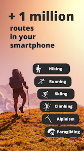
Relief Maps is your ultimate guide to all your mountain adventures.
Whether you're hiking, skiing, trekking, paragliding or even mountaineering, our 3D map makes it easy to find your way.
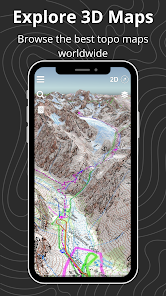
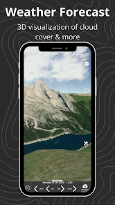
See the USGS maps as you've never seen it before in 3D!
Hiking to an area with no internet connection? No problem! Our gps app offers offline maps so you can continue your navigation even without a network. You can download USGS maps and use them in offline mode, so you'll always be sure of your position and direction.
Hiking :
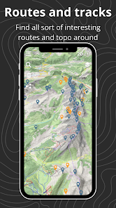
Find hikes nearby, our route catalog will help you find interesting trails all around you, whether you just want to go for a stroll or a sporty hike.
Our route planning system also lets you easily plot your own routes, then export them to GPX.
Mountaineering :
Consult camp-to-camp and skitour topos with GPS tracks and easily find the start of your dream route! From Mont Blanc to Aiguille Verte via the whymper couloir, climb every peak in the Alps!
Enjoy the best 3D visualization available on Chamonix and the French Alps.
Climbing:
Stop searching for hours for the start of a route! Find the start of a route with the GPX tracks available in the app.
Trek :
A trek lasting several days? You can plan your adventure easily with Relief Maps.
Find a list of points of interest that will help you, refuges, free parking lots, water points, toilets, campsites & bivouacs etc.
Find the best paths on our topo and IGN maps, and calculate the distance, altitude difference and duration of your route easily.
Whether you're trekking on the PCT or on the Appalachian Trail Relief Maps goes everywhere with you!
Ski touring :
Explore the mountains on skis with our ski touring tools.
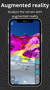
Analyze the terrain with augmented reality or 3D slope maps.
Take advantage of detailed weather forecasts with snowfall, temperatures by altitude, etc.
Consult skitour and camp-to-camp topos all over France and Europe.
Enjoy the best 3D visualization available on Chamonix and the French Alps.
Paragliding :
Used by many Xalps athletes, the app offers you all the tools you need for paragliding:
- Precise paragliding weather, wind, thermals, etc.
- Map of the best-known thermals
- Glide ratio calculator
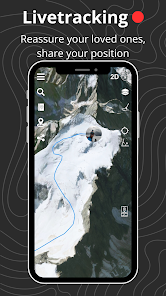
- Live tracking
- Track replay
Downhill skiing:
- Find the piste maps of major resorts such as Park City, Breckenridge, Jackson Hole and many others.
Free features :
- 3D map consultation
- Route planning
- Nearby routes
- Hiking, walking, mountaineering, climbing, ski touring, mountain skiing, walking and paragliding routes
- Points of interest (refuges, water points, free parking, etc.)
- Track recording
- GPX track replay
- Track synchronization with Suunto watch
- Augmented reality
- Glide calculation (paragliding)
Premium :
- Off-line maps
- Livetracking
- IGN map
- Weather forecasts
- Route saving/tracking
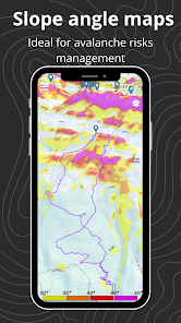
- Slope maps (for avalanche risk in ski touring)
- Winter map
- USGS Maps
- GPX import/export
Maps:
- USGS topo
- USGS satellite
- 3D terrain
- IGN free map
- IGN scan
- IGN satellite
- Avalanche slope
- Satellite
- Swisstopo
- Swisstopo satellite
- osm summer
- osm winter
--
Premium subscription : 29.99€/an
Terms of use: https://reliefmaps.io/terms.html
Privacy policy: https://reliefmaps.io/privacy.html
Whether you're hiking, skiing, trekking, paragliding or even mountaineering, our 3D map makes it easy to find your way.
See the USGS maps as you've never seen it before in 3D!
Hiking to an area with no internet connection? No problem! Our gps app offers offline maps so you can continue your navigation even without a network. You can download USGS maps and use them in offline mode, so you'll always be sure of your position and direction.
Hiking :
Find hikes nearby, our route catalog will help you find interesting trails all around you, whether you just want to go for a stroll or a sporty hike.
Our route planning system also lets you easily plot your own routes, then export them to GPX.
Mountaineering :
Consult camp-to-camp and skitour topos with GPS tracks and easily find the start of your dream route! From Mont Blanc to Aiguille Verte via the whymper couloir, climb every peak in the Alps!
Enjoy the best 3D visualization available on Chamonix and the French Alps.
Climbing:
Stop searching for hours for the start of a route! Find the start of a route with the GPX tracks available in the app.
Trek :
A trek lasting several days? You can plan your adventure easily with Relief Maps.
Find a list of points of interest that will help you, refuges, free parking lots, water points, toilets, campsites & bivouacs etc.
Find the best paths on our topo and IGN maps, and calculate the distance, altitude difference and duration of your route easily.
Whether you're trekking on the PCT or on the Appalachian Trail Relief Maps goes everywhere with you!
Ski touring :
Explore the mountains on skis with our ski touring tools.
Analyze the terrain with augmented reality or 3D slope maps.
Take advantage of detailed weather forecasts with snowfall, temperatures by altitude, etc.
Consult skitour and camp-to-camp topos all over France and Europe.
Enjoy the best 3D visualization available on Chamonix and the French Alps.
Paragliding :
Used by many Xalps athletes, the app offers you all the tools you need for paragliding:
- Precise paragliding weather, wind, thermals, etc.
- Map of the best-known thermals
- Glide ratio calculator
- Live tracking
- Track replay
Downhill skiing:
- Find the piste maps of major resorts such as Park City, Breckenridge, Jackson Hole and many others.
Free features :
- 3D map consultation
- Route planning
- Nearby routes
- Hiking, walking, mountaineering, climbing, ski touring, mountain skiing, walking and paragliding routes
- Points of interest (refuges, water points, free parking, etc.)
- Track recording
- GPX track replay
- Track synchronization with Suunto watch
- Augmented reality
- Glide calculation (paragliding)
Premium :
- Off-line maps
- Livetracking
- IGN map
- Weather forecasts
- Route saving/tracking
- Slope maps (for avalanche risk in ski touring)
- Winter map
- USGS Maps
- GPX import/export
Maps:
- USGS topo
- USGS satellite
- 3D terrain
- IGN free map
- IGN scan
- IGN satellite
- Avalanche slope
- Satellite
- Swisstopo
- Swisstopo satellite
- osm summer
- osm winter
--
Premium subscription : 29.99€/an
Terms of use: https://reliefmaps.io/terms.html
Privacy policy: https://reliefmaps.io/privacy.html
Updated on
Safety starts with understanding how developers collect and share your data. Data privacy and security practices may vary based on your use, region, and age. The developer provided this information and may update it over time.

No data shared with third parties
Learn more about how developers declare sharing

This app may collect these data types
Location, Personal info and 2 others

Data is encrypted in transit

You can request that data be deleted
Ratings and reviews
4.3
3.34K reviews

thew
- Flag inappropriate
November 21, 2022
Can't think any reason to opt for this app when Google Earth is simply better in every single conceivable way: better ui, smoother and higher quality graphics, more details & features, and settings options that actually work. This app can't even change from metric to imperial units: the option is listed in settings but elevations remain in metric measurements no matter. Lame.
18 people found this review helpful

Kiefer Wallace
- Flag inappropriate
March 12, 2024
I am enjoying the interface and the "workshop" for self tracking and map building. Just pretty slow it seems. Other than that it's everything I wanted in a mapping toolkit imaging included

hossein korrani
- Flag inappropriate
November 30, 2023
A wonderful experience, for me being in Iran almost cut from all over the world, seeing trecks on remote mountains here was very cool. I use the free version since there is no possibility for us to pay for anything online here. There are sometimes some bugs at least on the free version. I will be more than happy to help find bugs for developers, my way to thank them.....
5 people found this review helpful
What's new
-bug fixes


